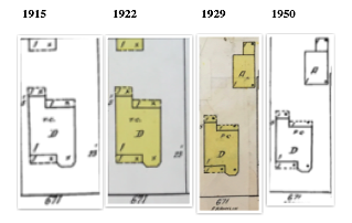
671 Franklin Street Sanborn Maps
Title
671 Franklin Street Sanborn Maps
Creator
Sanborn Map Company
Subject
American Period
Historic Archaeology
Heritage
Description
Compilation of Sanborn maps of the 671 Franklin Street residential property from 1915 to 1950
Contributor
Brady, Kiersten
Date
1915-1950
Type
Still Image
Files
Collection
Citation
Sanborn Map Company, “671 Franklin Street Sanborn Maps,” Santa Clara University Digital Exhibits, accessed July 3, 2026, https://dh.scu.edu/exhibits/items/show/1482.
Item Relations
This item has no relations.