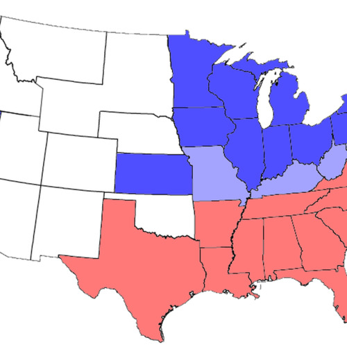
File:USA Map 1864 including Civil War Divisions.png
Title
File:USA Map 1864 including Civil War Divisions.png
Creator
Wikimedia user
https://commons.wikimedia.org/wiki/File:USA_Map_1864_including_Civil_War_Divisions.png
https://commons.wikimedia.org/wiki/File:USA_Map_1864_including_Civil_War_Divisions.png
Subject
Civil War
Description
English
Division of states during the civil war: blue = Union, including those admitted during the war; light blue = border, some of which had both Unionist & Confederate governments; red = Confederate; white areas were not states before or during the war.
Deutsch
Karte der US-Bürgerkriegsparteien Stand 1864
Publisher
Wikimedia
https://commons.wikimedia.org/wiki/File:USA_Map_1864_including_Civil_War_Divisions.png
https://commons.wikimedia.org/wiki/File:USA_Map_1864_including_Civil_War_Divisions.png
Contributor
Wikimedia and Wikimedia users
current 20:14, 3 July 2006 Thumbnail for version as of 20:14, 3 July 2006 784 × 488 (25 KB) Tom (talk | contribs) adjusting colors and formatting
04:12, 24 August 2005 Thumbnail for version as of 04:12, 24 August 2005 812 × 503 (34 KB) Tom (talk | contribs) {{GFDL}} United States Civil War Division in 1864 - slightly modified from one on Wikipedia.
Date
created in 2005/2006
Type
Image graphic
Format
PNG Image
(784 × 488 pixels, file size: 25 KB, MIME type: image/png)
(784 × 488 pixels, file size: 25 KB, MIME type: image/png)
Source
Wikimedia
https://commons.wikimedia.org/wiki/File:USA_Map_1864_including_Civil_War_Divisions.png
https://commons.wikimedia.org/wiki/File:USA_Map_1864_including_Civil_War_Divisions.png
Language
English and Dutch
Coverage
Civil war era U.S.
Rights
Permission is granted to copy, distribute and/or modify this document under the terms of the GNU Free Documentation License, Version 1.2 or any later version published by the Free Software Foundation; with no Invariant Sections, no Front-Cover Texts, and no Back-Cover Texts. A copy of the license is included in the section entitled GNU Free Documentation License.
w:en:Creative Commons
attribution share alike This file is licensed under the Creative Commons Attribution-Share Alike 3.0 Unported license.
You are free:
to share – to copy, distribute and transmit the work
to remix – to adapt the work
Under the following conditions:
attribution – You must give appropriate credit, provide a link to the license, and indicate if changes were made. You may do so in any reasonable manner, but not in any way that suggests the licensor endorses you or your use.
share alike – If you remix, transform, or build upon the material, you must distribute your contributions under the same or compatible license as the original.
Collection
Citation
Wikimedia user
https://commons.wikimedia.org/wiki/File:USA_Map_1864_including_Civil_War_Divisions.png, “File:USA Map 1864 including Civil War Divisions.png,” Santa Clara University Digital Exhibits, accessed February 22, 2026, https://dh.scu.edu/exhibits/items/show/5415.
Embed
Copy the code below into your web page
Item Relations
This item has no relations.
